Geographic Location
and Boundaries
Discover where Nijrab lies, how it’s shaped, and what defines its borders.
Where is Nijrab District?
A brief overview of Nijrab’s location within Kapisa and Afghanistan, highlighting its geographical significance.
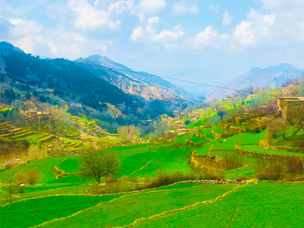
Nijrab District of Kapisa Province is located 35 kilometers from Mahmood Raqi, the provincial capital of Kapisa, and 115 kilometers northeast of Kabul. It forms a lush green valley. It is bordered to the north by Panjshir Province (Lalan and Shamiana Passes), to the east by the Tagab and Alasay districts (with high mountains such as Satah Aj and Parzhghan), to the south by Panjshir and Laghman provinces (with dusty hills leading to the Panjshir River and Bagh Dara), and to the west by Mahmood Raqi and Kohband districts (with low mountains like Ashoqan (Ashoka), and villages such as Darnama and Bulghin).
The total area of the district is approximately 585 square kilometers. Based on the estimated 1389 (2010) census, the total population is about 114,633 people, which means that about 196 people live per square kilometer.
The district center is called Shahrawani, located on a relatively flat area outside the valley with an average elevation of 1,400 meters above sea level.
The name “Nijrab” is composed of five letters, and correspondingly, the district consists of five main valleys and two sub-valleys. These valleys lie on the slopes of the western Hindu Kush and stretch from north to south. They are:
- Kalan Valley
- Farkhshah Valley
- Ghaus Valley
- Pata Valley
- Pachaghan Valley
The two sub-valleys are known as Pacha Ghan and Giyawa. The “Kharej Darah” (outer valley) is relatively flat compared to the other valleys of Nijrab, serving as the gateway to Pata, Ghaus, Kalan, and Farkhshah valleys. For this reason, it has been an important passageway since ancient times.
The high peaks in the northern part of Nijrab (such as Shamiana and Lalan passes) with their perpetual snow and numerous springs, irrigate the valleys and contribute to the pleasant climate, enhancing the natural beauty of the district. Particularly during the solar spring (vernal equinox) in the northern hemisphere, the district remains lush and vibrant.
Exact Location on the Map
Thus, Nijrab District lies between 34°55’30” and 35°11’10” north latitude and between 69°29’30” and 69°48′ east longitude.
Where Culture, Nature, and Community Thrive Together
Natural Geography of Nijrab District
A – Structure and Landforms of Nijrab District:
The natural features of a region are of significant scientific and practical interest for scholars and researchers in the study of various issues. Before the Pre-Cambrian period, the entire country was covered by an ocean called the Tethys. Over time, different geological periods followed, each with distinct characteristics. Traces of these various geological periods can be found throughout the country in varying amounts.
If we analyze the mountain ranges, geological matters, natural environment, topography, climate, settlement patterns, economic activities, and administrative divisions of Nijrab District, its effectiveness and benefits will become more evident. The mountain ranges of Afghanistan are a key natural feature that disrupts the arid nature of the area, creating favorable conditions for mountain rainfall. The existence of catchment areas, snowfields, and glaciers in some of the higher regions of the Pamir, Hindu Kush, and other Afghan mountains has allowed agriculture to develop, maintaining the lushness and vitality of the mountain range.
Land Structure:
A large portion of Afghanistan’s land was formed during the most recent geological period (Cenozoic, Tertiary period). This includes the main and secondary Hindu Kush ranges, the Baba Mountains, the Tiri Band of Turkestan, the Spin Ghar, the Sulaiman Ghar, the Siyah Kooh, the Gul Kooh, and the Chegai Mountain. All these mountain ranges emerged during different geological periods.
The structure and natural features of Nijrab District, like other parts of Afghanistan, have been shaped by tectonic activities or forces related to the Earth’s crust over the course of history, starting from the Pre-Cambrian period. This process has continued for nearly 4 billion years.
The landforms of Nijrab District are the result of numerous geological processes that have shaped the natural environment, providing the region’s people with a suitable place for settlement. Features such as elevations, depressions, folds, tectonic fractures, and other landforms are evidence of this.
Since the Hindu Kush connects with the Himalayan mountain range, its system, after the Mesozoic period, rose from beneath the waters and formed high mountain peaks, turning former ocean depths into mountain ranges. Nijrab District is also influenced by the branches of the Hindu Kush, which have created favorable weather conditions for this valley. Therefore, it is important to briefly discuss the significance of the Hindu Kush mountain range.
The Hindu Kush Mountain Range:
Afghanistan is a mountainous country, and the Hindu Kush, which is part of the larger Himalayas, is a major natural feature. The ancient name for this range was the Caucasus of India, located between 34° and 37° north latitude and 68° to 75° east longitude. The Hindu Kush divides Afghanistan into two geographical regions, separating the Kabul and Helmand river basins from the Amu Darya basin.
The presence of the Hindu Kush means that the flow of water in Afghanistan moves in various directions. The natural resources of the country are hidden within this mountain range, and it forms an important wealth in terms of minerals. Its watersheds also contribute to agricultural development. The forests, grazing areas, and diverse plant life found in the valleys of the Hindu Kush have helped establish settlements, although transportation and communication lines face challenges in many parts of the country. However, with advances in technology, this issue is no longer as significant, as the benefits of the Hindu Kush far outweigh these challenges. The Hindu Kush is one of the most well-known and largest mountain ranges in Afghanistan, extending over 600 kilometers from the Pamir to the southwest, separating the glaciers of the Karakoram from the rest of the country.
To better explain the geographical features of the Hindu Kush, it is useful to divide it into three parts:
If we analyze the mountain ranges, geological matters, natural environment, topography, climate, settlement patterns, economic activities, and administrative divisions of Nijrab District, its effectiveness and benefits will become more evident. The mountain ranges of Afghanistan are a key natural feature that disrupts the arid nature of the area, creating favorable conditions for mountain rainfall. The existence of catchment areas, snowfields, and glaciers in some of the higher regions of the Pamir, Hindu Kush, and other Afghan mountains has allowed agriculture to develop, maintaining the lushness and vitality of the mountain range.
A – Eastern Hindu Kush:
This is one of the largest mountain ranges in Afghanistan. It stretches between 70° and 75° east longitude, from the northeastern Pamir to the southwest, ending at the Anjuman Pass or Priyan, which separates the Panjshir Valley from Badakhshan. The range includes territories near the Karakoram, the eastern Pamir, and the border with the People’s Republic of China, forming high-glacier regions in the Gilgit region and Jammu and Kashmir, which separate Afghan soil from those areas.
The eastern Hindu Kush has a length of approximately 360 kilometers, with an average height of over 5,000 meters. Its peaks are covered in permanent snow and ice, and there are many glaciers in the area. The distance from north to south is about 230 kilometers, and it stretches between the cities of Fayzabad and Mehtarlam, representing the northern and southern ends of the Eastern Hindu Kush.
B – Western Hindu Kush:
The western Hindu Kush is the second-largest mountain range in Afghanistan. This range stretches 240 kilometers from the Khawak Pass in the northeast to the Aq Rabat, located north of Bamyan. Its width varies from its starting point to its end, reaching up to 100 kilometers at its widest. The valleys of Panjshir and Ghorband limit it from the south, while the Andarab and Tala wa Barfak valleys border it from the north, giving the range an almond-like shape.
C – Sub-ranges of the Hindu Kush:
To the north and south of the main Hindu Kush range, there are several sub-ranges that make the lands of the northern and southern regions extremely mountainous, with narrow and winding valleys. These sub-ranges can be summarized as follows:
- Sub-ranges to the north of the Hindu Kush: These include many smaller and larger mountain ranges, such as the Wakhan Range, the Shighnan and Darwaz ranges, and the Khwaja Mohammad Range.
- Sub-ranges to the south of the Hindu Kush: These include many smaller mountain ranges that are equally important for Afghanistan’s geography. These ranges cover the northern regions of Pashtunistan and the eastern provinces of Afghanistan.
In this section, we will discuss only the southern sub-ranges of the Hindu Kush, which have provided suitable living conditions for the people of Nijrab District. This area is a gift of nature for the district
Southeast of Anjuman Pass: As previously mentioned, the large mountain range continues to the south of the main Hindu Kush range. This sub-range is the largest among all the sub-ranges of the Hindu Kush and occupies a vast area. It is named differently at various points, and we can mention the following:
- Marsmar Mountain: This mountain is located about 10 kilometers southeast of Anjuman Pass and extends southward, reaching the Katul Arib, which connects the first part of Panjshir with the western Nooristan valley. The highest peak of this mountain is near the Chamar Pass, which was historically significant when Amir Timur traveled to suppress the people of western Nooristan (then known as Kafiristan). The mountain rises to an elevation of 6,060 meters, and its lower areas are covered by lush forests, but the western side has no trace of trees.
- Kiyosht Mountain: Starting from the Katul Arib, this mountain continues south to the north of the market of Elishang and the western areas of Alingar. A relatively large branch splits from the middle of this mountain, continuing westward and covering all the upper parts of the Elishang River, including the Farajgan region.
- Kavun Mountain: This mountain is located in the western part of the Elishang valley and the eastern part of the Tagaab region in Kapisa province. It rises to a height of 4,277 meters, with areas of permanent snow and glaciers around its peak.
Famous Passes of Nijrab District
Kotal Darah Kalān (Shamyāna):
This pass is located in the northern part of Darah Kalān, connecting Darah Kalān of Nijrab district to Abdullah Khail valley in Panjshir province. This pass is covered with forests and has permanent snow, with an elevation of 4900 meters, making it the highest peak of Nijrab district. Even when travelers reach an altitude of 4100 meters, they experience oxygen depletion due to a sharp ridge, which the people of Nijrab refer to as “planting.” This means when they reach this area, they say someone has been “planted.” As a result, they carry onions to eat or walk more to alleviate this issue. The pass is rocky and has dangerous cliffs and breaks. Traveling through this area, especially in winter, is extremely difficult. Due to its strategic location, during the jihad era, people of Panjshir province passed through this pass to protect themselves from bombardment by the Red Army and the communist government of that time. Many people from Panjshir and Nijrab were killed during this period. This pass forms a permanent Snowline, and crossing it in winter is impossible. On the southern side of the pass (Abdullah Khail valley in Panjshir), the slope is not steep. A large cliff formed by tectonic activity during the third geological era is located on the western side of the pass, reaching a depth of over 3200 meters. The people of Nijrab colloquially call it “Dandana.”
In the southern part of this pass, there is a glacial basin, likely formed during the fourth glaciation, with a significant area of more than two kilometers. Its water flows toward the Abdullah Khail valley in Panjshir. There are also several smaller peaks in Darah Kalān that are locally named and begin at an elevation of 3200 meters and decrease to 1600 meters (e.g., Jamin Mountain, Wakah Mountain, Aiyar Khail Mountain, and the White Mountain of Ibrahim Khail village, which are covered with forests of oak, almonds, and junipers, though the summit of Chouti Mountain in Ibrahim Khail village is rocky and barren). These mountains are important for the villagers of this valley.
It is worth mentioning that the northeastern part of Darah Kalān, starting at an elevation of 2400 meters and continuing down to 1720 meters (e.g., Kiar Mountain, Abikhail Mountain, and Serghwein Mountain), is filled with juniper and oak trees. Serghwein Mountain has large pastures for livestock. Finally, in the western part of Darah Kalān, Chasht Koohe Mountain is rocky and devoid of natural forests.
The small mountains of Darah Kalān have created several springs that even irrigate agricultural lands in some of the valley’s villages (e.g., Somaana Spring, Salarkhaneh Spring, Zaghine Spring, etc.).
Kotal Darah Pathe:
This pass is full of forests and juniper trees and has many fractures. These fractures create permanent snow reservoirs in the area, which results in hundreds of springs emerging in the middle of the valley, forming a lake. Additionally, there is a large pond at a higher altitude, about one meter deep, with a radius of about one kilometer. The summit of Nalkhe, a rocky peak, retains snow until late spring. The summit of Vistar also has no significant height and is mostly rocky, making it easy to travel from Vistar village in Nijrab district to Qash Daraz village in the Dara Hazara region of Panjshir. The summit of Khwajah Ghar in this pass is connected to Perzghan Mountain in Laghman province. In 1894, Amir Abdurrahman Khan used this route to attack Kafiristan, later renaming it Nuristan after its conquest.
Kotal Darah Farakhshah:
Kotal Darah Farakhshah is also one of the famous passes of the Nijrab valley. Its northeastern part (Kundee Mountain) forms the boundary between Kapisa province and Hesarak district in Panjshir province, with elevations ranging from 4300 meters to 1400 meters. Due to the accumulation of permanent snow on its towering peaks, it forms a lake full of water during all seasons, known as the Farakhsha Sea. This lake starts at the base of Kundee Mountain and merges with the sea of Darah Kalān at the valley’s mouth.
Among the famous passes in this valley are the Ghul Akhakhil Mountain, which covers the western part of Farakhshah valley, Umar Khail Mountain, Roi Mountain, and Bulna Mountain, which are rich in natural forests of oak and juniper. The elevations of these mountains range from 2800 meters to 1400 meters.
Kotal Darah Ghosh:
Kotal Darah Ghosh is divided into two main sections:
- Kotal Kherok, which starts from the eastern part of Ghosh and connects to Kili village in Ghosh valley and Kili Mountain.
- Kotal Azhulān, which starts from the western part of Ghosh and also connects to Kili village and Kili Mountain.
These two famous passes are rich in juniper, oak, and juniper forests, making them the main source of juniper exports from Nijrab.
Kotal Pache Ghān:
Kotal Pache Ghān, a significant pass in the Nijrab valley, is one of Afghanistan’s historical pathways. The summit of Pateek, in Perzghan village, separates Kapisa province from Laghman province. Additionally, the Ghain Mountain in this pass separates Nijrab from the Ashpi village of Tegar district. This pass is 55% covered by forests of juniper, oak, and juniper, and some areas have wild almonds. The elevations of the pass start from 3820 meters and end at 900 meters at the Afghanieh Mountain.
Geomorphological Structure of Nijrab District
Upon studying the geomorphological structure of the Nijrab valley, it becomes evident that, like other valleys in the Hindu Kush, it was formed by glaciation. In fact, the valleys of Nijrab are glacial valleys that resulted from glacial retreat and sediment deposition (glacial moraines). To explain further, it is essential to consider the glacial periods.
The significant glacial periods of the Quaternary era, particularly the Pleistocene, are recognized. Although earlier glacial periods are known from the Paleozoic and Precambrian eras.
Two major glacial periods are known during the Quaternary period, separated by the main interglacial period of Mindel-Riss. Each of these two glacial periods is divided into several smaller stages, and they have progressive or delayed phases, which makes determining the absolute age of glaciers more challenging.
In addition to forming valleys, glaciers also create other formations, which are briefly mentioned:
- Horm: Narrow peaks or summits of mountains formed by glacial movement and erosion.
- Arêtes: Sharp ridges formed from the erosion of narrow peaks or summits during glacial movement.
- Triangular: If part of a mountain is eroded by glaciers, it forms a triangular shape, which is referred to as a “Triangular” formation.
- Triang Cated: The part of the peak formed after the mountain is cut by a glacier or the tip of the triangular formation is called “Triang Cated.”
It can clearly be proven that the small mountains of Darah Kalān, Farakhshah Valley, Pathe Valley, Ghosh Valley, and Pache Ghān are examples of these formations.
Glacial Erosion, Movement, and Sedimentation in the Nijrab Valley:
The geomorphological evidence in the Nijrab valleys clearly shows that, as glaciers moved, they accumulated layers of ice on top of one another, leading to increased pressure. This pressure generated heat, causing the glacier’s surface to melt. The large chunks of ice, along with the materials and debris along their path, were transported and eroded. The reduction in pressure and temperature change led to sediment deposition, leaving behind three types of glacial features in Nijrab district:
- Glacial Lakes: The movement of glaciers carved out depressions, which, upon melting, formed glacial lakes. Examples include the lakes in the upper parts of Darah Kalān, Abdullah Khail valley in Panjshir, as well as the lakes in Kotal Darah Pathe and Dara Hazara in Panjshir.
- Glacial Moraines: Glacial moraines are rocks and debris carried by glaciers, which can be observed along the slopes of Shamyāna Kotal, Darah Kalān, and parts of Ghosh and Pathe valleys.
- Glacial Valleys: Glaciers eroded large portions of land, creating U-shaped valleys, which are referred to as glacial valleys. Examples of this include the valleys of Jamin in Darah Kalān to Ibrahim Khail village and from beneath Kundee Kotal in Farakhshah valley to the valley’s mouth.
Water runoff from glaciers (outwash) leads to the formation of glacial moraines, which are seen throughout the glacial valleys in Nijrab.
The geological signs show that, prior to the second era (Heliocene), during the second era (Quaternary), the third era (Cenozoic), approximately 1.5 million years ago, the entire Nijrab valley was surrounded by water, forming a closed basin. Through tectonic fracturing in the Naghlo Dam, a large fracture was formed, allowing water from the valley to gradually drain out. This process left behind three types of formations:
- Lower formations (sedimentary plains)
- Semi-sloping formations (for settlement, agricultural use, etc.)
- Upper formations (representing ancient periods of the valley)
These formations show the historical nature of the glaciation in Nijrab and the geological shifts that have taken place over millions of years.
Soil Characteristics of Nijrab
Since the Nijrab valley was formed by the retreat of glaciers, or in other words, the valleys of Nijrab were created as a result of the retreat of the most recent glacial period, it is composed of glacial moraine deposits and has fertile soil. In soil science, its soil type is referred to as Spodosol. Below is a brief explanation of the characteristics of this soil:
Spodosol: Spodosols are almost equivalent to the ancient podzols in areas with relatively high latitudes, where the vegetation is predominantly coniferous. Initially, fresh deposits are formed on the ground surface by water, wind, or glaciers. At the surface of these new deposits, a thin layer of plant remains may be mixed with mineral materials. In the new soil classification, this is called Entisol. Over time, the process of weathering (degradation) of minerals continues, and organic materials mix deeper with the decomposed sediment, leading to the formation of a thicker soil known as Inceptisol. Gradually, materials are leached from the A horizon (soil layer), and they accumulate in deeper layers, forming a well-developed B horizon. In the lower part of the A horizon, from which organic matter and clay are removed, an E horizon is formed. In this stage, a mature soil known as Spodosol has developed. In old soil classification, this soil is called Podzol, and it is considered one of the fertile agricultural soils.
Hydrology
Water Resources and Watersheds
No natural phenomenon exists in isolation, unaffected by its surroundings. All phenomena are interconnected, continuously changing under the conditions of time and space, involving inherent contradictions, and following an evolutionary path. These processes are governed by natural laws, and they cannot be separated from these laws. Accordingly, the formation of the landscape features and landforms of the Nijrab valley is directly and fundamentally linked to the issues of hydrography and meteorology. It has a significant impact on the creation of rivers and the distribution of surface water in the Nijrab valley.
It can be stated clearly that the water resources and watersheds of Afghanistan are formed by the Hindu Kush mountain range and its elevated points, especially the permanent snow in the Wakhan and Pamir regions, the eastern and western Hindu Kush, and the Baba mountains, which melt every spring and summer, providing flowing water in various watersheds. This is why the water volume in the rivers is higher in spring and early summer, and sometimes it becomes turbulent and stormy. The lack of sufficient vegetation on the surface of the land causes erosion and degradation of the land, especially in areas along rivers, occasionally destroying agricultural and fertile lands.
The flow of water in the rivers of Afghanistan is generally fast because the sources of the rivers or main riverbeds originate from high-altitude points and flow through steep valleys. This leads to a rapid process of erosion and land degradation, and the riverbed often becomes eroded, sometimes taking the form of a gorge.
Famous Rivers of Nijrab:
Kalan Valley River: This river originates from the 4900-meter-high Shamyana and Lalan passes (north of the Kalan valley). After irrigating the agricultural lands and trees of the villages of Jameen, Wakah, Ayyarkhail, Ibrahimkhil, Kiar, Abikhil, and Serghoyn, it joins the river in the Farakhshah valley and flows downstream out of the valley. During the spring season, it has continuous water flows that result in the destruction of agricultural lands, livestock, and gardens of the residents of this valley.
Ghaus Valley River: The Ghaus Valley River also originates from two passes: the Khairok pass in the east and the Gacholan pass in the west. They meet in the village of Kili, and the water irrigates all the villages of the valley. Ultimately, in the area of Dawlat Beikhil, it merges with the rivers of Kalan and Farakhshah valleys.
Pacheghan Valley River: The Pacheghan Valley River, like the Ghaus and Pata valley rivers, has two sources: the Pitak and Ghina passes. After traveling through the villages of Afghanieh and others, it merges with the other rivers of the valley.
Farakhshah Valley River: This river originates from the 3100-meter-high Kundi pass. After irrigating the lands of the villages of Laka Sachi, Omarkhail, and Roree, it joins the river in the Kalan valley and continues flowing downstream. This river also has continuous water flows during the spring season that cause the destruction of agricultural lands, livestock, and gardens in the valley.
Pata Valley River: The Pata Valley River in the Nijrab valley originates from two passes: Nalkha and Waisar. Both water sources join after traveling 800 meters and irrigate the agricultural lands of the villages of Nalkha and Waisar, stretching all the way to the village of Chahar Safah. Finally, in the area of Dawlat Beikhil, it merges with the rivers of Kalan and Farakhshah valleys.
Climate Characteristics of Nijrab
A Study in Four Dimensions
The climate of any region is shaped not only by its geographical location (latitude) but also by a complex interaction of elevation, atmospheric behavior, and time. In modern geographical and climatological studies, these elements are referred to as the four dimensions of climatic analysis: longitude, latitude, elevation (altitude), and temporal variation. When all four are considered together, a more accurate and scientific understanding of natural phenomena on Earth’s surface becomes possible.
Elevation, in particular, plays a decisive role in defining local climatic conditions, especially in mountainous regions like Afghanistan. The country’s diverse and rugged terrain contributes to a variety of microclimates. High mountain ranges act as climatic barriers, impacting wind flow, air pressure, and precipitation patterns. Consequently, Afghanistan’s climate is broadly categorized based on its altitudinal zones, ranging from arid lowlands to snow-covered highlands.
Several air masses and pressure systems influence Afghanistan’s weather patterns. In winter, cold polar air masses from Siberia push southward, sweeping across Central Asia and eventually reaching the Hindu Kush mountains, where they create cold fronts. These fronts result in heavy snowfall and freezing temperatures, especially in elevated valleys like Nijrab. Another significant climatic influence comes from the Atlantic maritime air mass, which develops around Iceland. This system forms a low-pressure center and moves southeastward into Afghanistan, bringing cyclonic precipitation and winter rainfall.
Nijrab District, located in Kapisa Province, experiences a climate strongly influenced by these global and regional systems. Its position within a mountain-locked valley gives it unique meteorological features. The western winds, which carry most of the moisture, enter the region primarily through the Shoqi Valley—a natural corridor for air movement. The surrounding highlands act as a buffer, protecting the valley from intense windstorms but also contributing to temperature extremes.
During winter, Nijrab experiences severe cold, with temperatures dropping as low as -38°C. Snowfall can reach up to one meter, particularly in the higher elevations. The duration of snow cover is extended due to limited sunlight and the insulating effect of the mountains. These harsh conditions make winter one of the most challenging seasons for residents, especially in remote areas.
Summer in Nijrab is relatively mild and humid, though the temperature rarely exceeds 36°C. Humidity levels are higher than in the southern parts of the country due to mountain-fed streams and vegetation. Spring and autumn are considered the most pleasant seasons, offering clear skies, moderate temperatures, and refreshing breezes. These transitional seasons are ideal for agriculture and outdoor activities.
Overall, Nijrab’s climate can be classified as monsoonal continental, with pronounced seasonal changes and notable precipitation during winter and spring. Its geographical configuration—particularly altitude and orientation of the valleys—alongside large-scale atmospheric movements, defines its distinctive climate. Understanding these factors is essential not only for local development planning but also for environmental management and agricultural sustainability.
Have Questions or Insights About Nijrab’s Geography?
We’d love to hear from you!
Whether you’re a researcher, a student, a local resident, or simply curious about the geography of Nijrab District, feel free to reach out